|
Hello Friends,
A few people asked for an answer key to check their work when they practice the 5 Themes of Geography "Cut and Sort" at home to review for their quiz on Monday. I have two different versions of this answer key, and they are linked below. I hope they are helpful! The version linked here does not have the complete detail from the cut and sort cards. For example, if the detail actually says "Lines of latitude measure how far north or south of the Equator a place is located", this answer key might say just "Lines of latitude..." For many details I gave just the first few words. The version linked here still looks like an uncut copy of our original handout. To help you understand which theme and details are connected on this copy, I marked them with different colored stars. This version might be helpful because I hand-wrote in a few extra details and underlined some key words for students who didn't understand why a detail connected with a particular theme. Happy Studying! In class today I handed out a "5 Themes of Geography Review" sheet/packet. Before to Social Studies tomorrow (Wednesday), please help yourself to one of these packets -- extras are, as usual, in my Extra Handouts: Social Studies basket -- and make the front page of the packet match the notes below. We did this together in class. You do not need to do anything with the second page yet. We will talk tomorrow about how to use this to review for Monday's quiz. Thanks! See you soon. :) 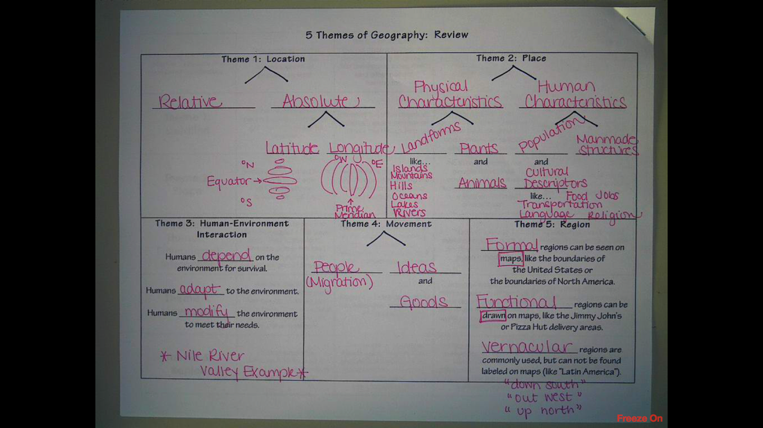 Today students had class time to complete a 4-sided packet titled "The Five Themes of Geography". The answers to fill in the blanks in this packet came from the slideshow in the post below and/or from pages 8-13 in a textbook available on my back counter titled Eastern Hemisphere.
You do not need to complete this packet. However, prior to Social Studies class tomorrow, you need to have a copy of this packet in your possession. Grab one from my "Extra Handouts: Social Studies" basket, put your name on it, and write "ACT" at the top so that I know why it isn't done when you get to class tomorrow. Then, spend 5 minutes or so flipping through the slideshow in the post below so that you have some prior knowledge about the 5 Themes of Geography before our next class. If you have any questions, send me a message or leave it in the comments below and I'll get back to you as soon as possible. See my planner. :) Your Atlas Packet, all pages except those two time zone questions, are due tomorrow.
Also, please be sure you know where your Map Projections packet is from the middle of last week. It had three projections, and a chart where you recorded first impressions, what looked accurate, and what looked distorted. We will be going over this tomorrow. Hello ACT Friends,
Tonight for homework, all sixth graders are doing a packet. No one had time to get started on it in class; I handed it out as they walked out the door. I will give (or I have given) this to you before you go home today too. Here's an overview of the directions I gave related to the packet... You're going to be looking at three different mapmaker's pictures of planet Earth. For each map, when you look at it you should record (in the chart on the second sheet of paper in the packet) your first impression of that map. This means, what is the first thing that pops into your head when you look at that map. There is no right or wrong answer, just record YOUR first impression/ thought. You will also be recording (in the chart on the second sheet of paper in the packet) what seems to be accurate about each map and what seems to be distorted. In the accurate box for each map, note parts of the map that look the size you think they are in real life. In the distorted box for each map, note the parts of the map that do not seem to be anything like the size you think they are in real life. Then, after the chart is completely filled out, there are two questions at the bottom of the page. Please answer these to the best of your ability. The second question is an opinion...there is no right or wrong answer. This packet is due tomorrow. If you have questions, comment below and I'll try to clear them up for you ASAP. :) Hello ACT Friends,
Yesterday in class we were working on a sheet called "What is Geography" (front) and "Examples of Human Geography" (back). Today in class we will be finishing the chart on the back side for the Statue of Liberty, Jamestown Colony, and the Louvre Museum. The PowerPoint slide images we will be using in class today are available at this link. I would like you to pick at least one of these three remaining manmade structures, look through the pictures, and make your best guess at where it is and why it might be there. Don't feel like you need to do extra research, a good guess is all we're looking for...we will review/discuss in more detail tomorrow. Sound fair? Once you've made your guess for at least one of the three remaining manmade structures, please fill in that row of the chart and write ACT at the top of your paper so that I know why the other two rows might not be done. Good luck! I'll see you tomorrow! If you are interested in representing sixth grade this year in Bursley's Student Council
(organized by Srta. Wiley and Mrs. Duval), please complete the application linked with the button below by 9:15 am on Monday, Sept. 28. We started a video and a worksheet/notes page today. Before class begins tomorrow, please grab a "Human Footprint Video Questions" packet out my Extra Handouts: Social Studies basket and put your name on it. You may do this during Independent Work Lab time, during recess/lunch, or during a transition.
Please do not copy answers for the questions you missed from a classmate; that would be cheating. Instead, just get your blank packet out at the beginning of class tomorrow so that you are prepared to pick up where we leave off today. Thanks! |